Unmanned Systems Designed for the Frontlines
Emergency Response Solutions
High-performance drones for critical incidents — engineered to support first responders across every terrain.
BOOK A DEMO

Overview

Built for Crisis. Powered by Insight.

Emergencies don’t wait, so your response shouldn’t either. ideaForge provides high-performance, durable unmanned aerial systems (UAS) designed for search and rescue, public safety, and disaster management.
Our UAVs give teams persistent situational awareness to help them respond quickly, accurately, and confidently to everything from hurricanes and wildfires to urban search and flood relief. ideaForge drones, which are built for frontline use, simplify operations while retaining responder control by combining intelligent autonomy, modular payloads, and endurance-tested dependability.

Challenges Emergency Teams Face Today

Modern responders need better tools to overcome operational blind spots, especially in high-risk environments.

Common limitations include:

  • Short flight endurance limiting coverage of large or remote disaster zones
  • Poor night vision/thermal capabilities hindering effectiveness after dark
  • Limited range preventing beyond-line-of-sight operations
  • Lack of real-time intelligence and AI support, reducing speed and accuracy of decisions

The ideaForge Edge

Built to Overcome Real-World Challenges

Flight Endurance

Up to 120 minutes of continuous operation

Operational Range

Up to 9.3–15.5 miles real-time control

IP54

Ruggedness

MIL-STD tested; IP54-rated dust and water resistance

Multi-Sensor Payloads

EO/IR, thermal, megaphone, multispectral, and more

Smart Flight Controls

Guided takeoff, waypoint navigation, and fail-safe return via BlueFire!

Smarter Situational Awareness

Eyes in the Sky. Control on the Ground

24/7 Aerial Coverage

Operate day or night with EO/IR and thermal payloads for complete visibility.

Smart Mission Planning

Use BlueFire to set waypoint-based routes for systematic, efficient aerial coverage.

Live Command Center Feeds

Stream encrypted real-time visuals to Emergency Ops Centers (EOCs).

High-Res Payloads

Detect people, damage, or danger zones with precision optical zoom and thermal imaging.

Resilient Performance, Anywhere

Built to withstand. Designed to Endure.

All-Weather Ready

Built to perform in wind, altitude, and harsh environments with IP54-rated dust and water resistance.

Modular Payload Integration

Choose from EO/IR, multispectral, thermal, and mapping-grade cameras.

Rugged, Rapid Deployment

VTOL and mission-ready platforms designed for quick setup and launch in dynamic environments.

Smart Fail-safes

Failsafe systems for auto-return, low battery, and lost comms ensure safe flight in uncertain environments.

ideaForge SWITCH UAV with NSN
FIXED WING VTOL

SWITCH UAV
All-Terrain Dominator

  • Hybrid VTOL built for extreme surveillance missions.
  • Use Case: Tactical ISR, persistent surveillance, border monitoring
  • Features: Vertical take-off and landing (VTOL), mapping-grade accuracy, secure comms

ORDER NOW
Over
10 Miles

Operational Range

Over
120 Minutes

Flight Time

Optical Zoom
25 X HD

Daylight Surveillance Payload

NETRA V4 PRO
Quadcopter

NETRA V4 PRO
Versatile Workhorse

  • Battle-tested performance for a wide range of tactical needs.
  • Use Case: Close-range surveillance, battle damage assessment, convoy protection
  • Features: Hand-launched, rugged, real-time video, GPS-denied navigation

ORDER NOW
Over
10 Miles

Operational Range

Over
90 Minutes

Flight Time

Optical Zoom
27 X HD

Daylight Surveillance Payload

Q6 V3 UAV
Quadcopter

Q6 V3 UAV- Agile and Powerful

  • High-payload quadcopter for mission flexibility.
  • Designed for: High-payload, long-endurance tactical missions
  • Features: High-altitude performance, AI-enabled analytics, multi-mission payloads

ORDER NOW
Over
50 Minutes

Flight Time

Up to
17.6 lbs

Take-off Weight

Compatible
2 Payloads

EO/IR

BlueFire Touch
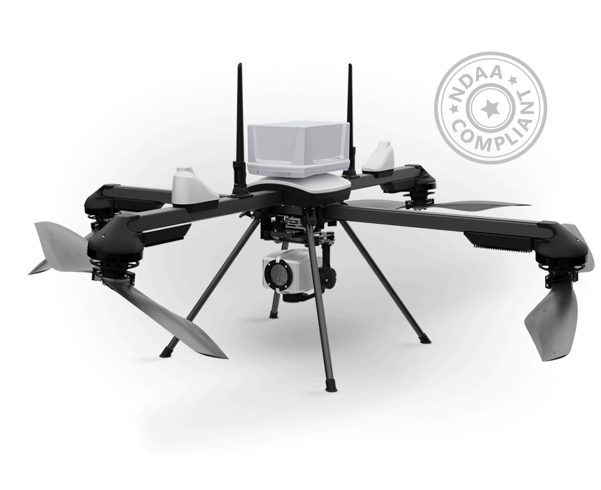
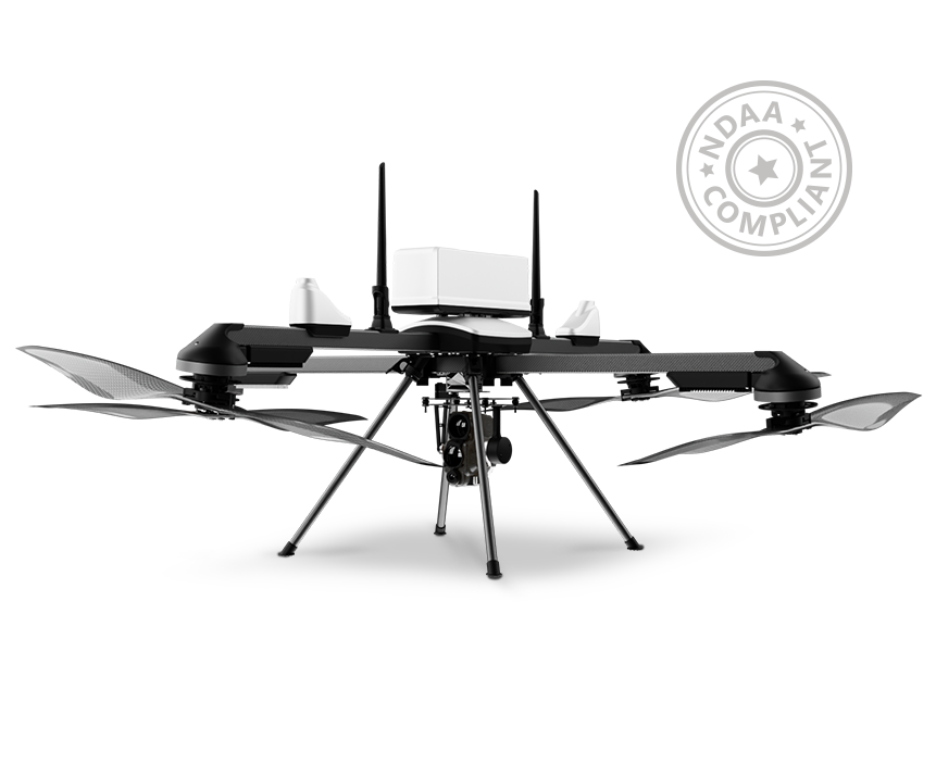
ideaForge UAV Solution
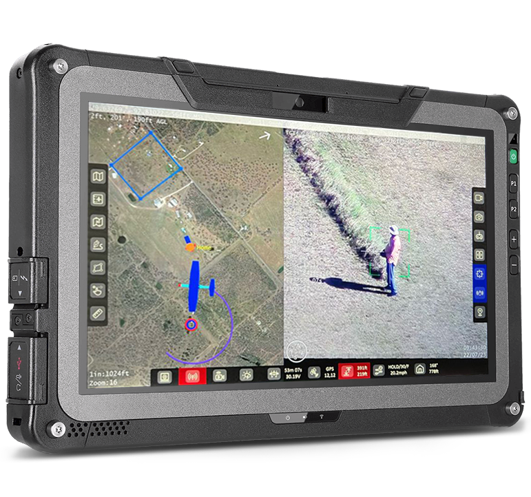
BlueFire Touch

BlueFire Touch, our GCS software, is built to plan and command both mapping and surveillance missions with the ability to pre-plan missions based on operational area and target locations via waypoint-based navigation.

  • Joystick-Free Control - Allows you to focus on your mission
  • Advanced Mission Planning Features - Check your area coverage and target location area along with a view of the coverage area
  • Autonomous Take-off & Landing
  • Fail-Safe Features - Communication Loss, Low Battery, High Winds.
BOOK A DEMO
BlueFire Live!
ideaForge UAV Software
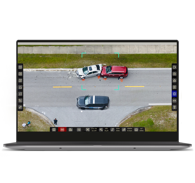
BlueFire Live!

  1. Control payload from a remote command location.
  2. Secured access to an encrypted live-stream.
  3. Enhanced night-time operations with thermal imaging.

Why ideaForge for Emergency Response?

First-Responder Focused

Solutions designed for law enforcement, disaster agencies, and rescue teams

Flight-Tested Reliability

750,000+ missions flown in real-world conditions

Secure & Compliant

NDAA-compliant, AES-encrypted, and built for U.S. public safety standards

Multi-Agency Integration

Easily deployed across Fire, EMS, Police, FEMA, and National Guard units

Precision Intelligence:

From GPS-denied navigation to AI-powered object detection

Ready to Respond. Built to Lead.

Take your emergency response operations to the next level—with eyes in the sky and control at your fingertips.