Hurricane Idalia, which hit parts of Florida, Georgia, and the Carolinas in August 2024, caused catastrophic flooding, widespread infrastructure collapse- bringing winds of over 125 mph. Roads were flooded, communities were left without electricity, and emergency services were overburdened. It served as a clear reminder of how frequently and with increasing intensity hurricanes have been occurring in recent years.
Every second matters when catastrophes of this magnitude occur. Making quick, well-informed decisions can mean the difference between life and death. Uncrewed Aerial Vehicles (UAVs) are proving to be invaluable resources in this changing environment, facilitating safer operations, quicker assessments, and more efficient disaster response.
UAVs are enabling responders to act with previously unheard-of speed and accuracy throughout the whole disaster management cycle, from preparedness to emergency relief and long-term recovery.
Why Hurricane Disasters Demand Rapid, Informed Action
Hurricanes are one of the most destructive natural disasters, often triggering a cascade of flooding, landslides, electrical outages, and building collapse. The affected region becomes extremely difficult to access within a short time, particularly if roads are impassable or communications lines are cut. Ground reconnaissance is too slow, while helicopters are costly, weather-dependent, and limited in deployment flexibility.
Drones provide a powerful alternative: they can be quickly mobilized, flown over impassable terrain, and record high-resolution data in real time—all without endangering responders.
UAV Applications in Hurricane Disaster Management
1. Risk mapping and pre-disaster readiness
UAVs can be used to monitor coastal defenses, map flood-prone areas, and evaluate vital infrastructure prior to a hurricane. Disaster management organizations can improve mitigation plans, plan evacuation routes, and use geospatial data to simulate worst-case scenarios by using aerial surveys to identify vulnerable areas.
Flood modeling and early warning system design are supported by the ability of drones fitted with photogrammetry software to produce intricate 3D terrain models.
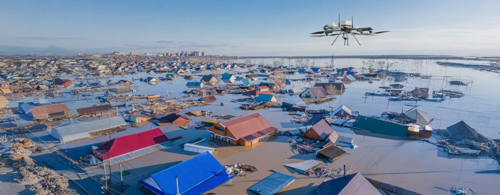
2. Evaluation of Damage Following the Storm
Accurate situational awareness is critical after a hurricane. Responders can swiftly examine vast regions and determine the degree of damage to homes, bridges, roads, and power lines thanks to UAVs.
By capturing high-resolution images and video, drones help authorities:
- Determine any remote or cut-off areas.
- Give rescue and relief efforts top priority.
- Record infrastructure damage for funding or insurance purposes.
- Cut down on the delays brought on by ground assessments
When time is of the essence, this aerial viewpoint expedites the decision-making process.
3. Search and Rescue in Hard-to-Reach Areas
Drones can be used by search and rescue teams to find people who are stranded when roads are flooded or blocked by debris. Even at night or in low light, UAVs equipped with thermal imaging can identify body heat signatures.
Drone live feeds help rescue teams coordinate more effectively and respond more quickly, which improves results and lowers the risk to human personnel.
4. Communication Support and Network Restoration
Communication blackouts are frequently caused by hurricanes damaging power lines, satellite links, and cell towers. By deploying communication payloads that allow voice and data transmission or serving as flying relays, UAVs can be utilized to momentarily restore connectivity.
When traditional infrastructure is compromised in remote or severely affected areas, this is particularly helpful for connecting emergency teams.
5. Monitoring Recovery and Rebuilding Efforts
Long after the storm has passed, drones are still useful. They assist in keeping an eye on reconstruction efforts, confirming the status of repairs, and guaranteeing that newly constructed areas comply with safety regulations. Additionally, UAVs help monitor the environment by spotting secondary hazards like erosion, unstable structures, and contaminated water.
Drone-generated images are used by insurance companies and aid organizations as impartial proof to back up claims and distribution of funds.
What Makes a UAV Appropriate for Hurricane Response?
Not all drones are designed for disaster response. Hurricane response requires UAVs that are:
- Rugged and weather-resistent, capable of surviving post-storm environments
- Fitted with high-resolution or thermal imaging payloads
- Long-endurance flight capable to cover expansive areas in efficient flight operations
- Simple to deploy in field environments, even by non-specialist operators
- Equipped with real-time data transmission for remote coordination
Rapid deployment capabilities, obstacle avoidance, and autonomous flight planning all contribute to safe and efficient operations in dynamic disaster areas.
How ideaForge UAVs Support Disaster Management
ideaForge design UAVs specifically for challenging missions in real-world environments—such as disaster management. UAVs such as NETRA V4 PRO and SWITCH UAV are utilized in post-disaster situations for expansive area mapping, continuous monitoring, and rescue assistance. With extended flight time, durable designs, and sophisticated imaging payloads, these platforms are built to work where conventional systems are not suitable.
Whether they’re overflying a flooded neighborhood or supporting search-and-rescue missions, our UAVs enable emergency responders to act faster and more clearly.
Future-Ready Disaster Response
As hurricanes become more intense and frequent with climate change, disaster readiness and quick response will also continue to progress. UAVs are already transforming the way the world approaches emergencies—shedding light when it’s most needed, reducing risk to responders, and accelerating recovery.
For governments, disaster management authorities, and humanitarian agencies, drones are no longer a choice—they’re necessary. With effective UAV systems and response strategies in place, communities can act more quickly, recover more intelligently, and rebuild more resiliently.