Human history is dotted with disasters, both natural and man-made. Each time disasters make news headlines, they raise questions on the efficacy of preventive measures, relief measures, and the quality of disaster response. The California fires that razed some of the most prominent addresses in Los Angeles, forcing hundreds of people out of their homes, raged on for weeks before firefighters working tirelessly around the clock were able to contain some of them.
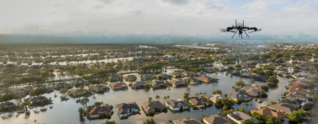
The US also experiences frequent hurricanes that cause massive destruction of property and prolonged disruption of civilian life, including access to electricity, healthcare, education, and daily necessities. Disaster response has traditionally relied on human response teams, ground vehicles, and manned aircraft that assess damage, locate survivors, and deliver aid. These traditional methods often face challenges of accessibility, speed, and risk to human life. Unmanned aerial vehicles (UAVs) can revolutionize disaster response in the United States by providing faster, safer, and smarter solutions. Their ability to reach hazardous areas quickly, capture real-time data, and enhance coordination efforts makes them indispensable tools in emergency management.
Why UAVs Are Game-Changers in Disaster Response
In disaster scenarios, time is critical. The unique advantage of UAVs lies in the ability to deploy them within minutes, providing immediate aerial surveillance and real-time data such as the extent of damage, the most impacted areas, etc. Unlike human disaster relief teams, which may take hours or even days to reach affected areas, UAVs can quickly map damage, assess risks, and help prioritize rescue efforts. For instance, after hurricanes or wildfires, UAVs can be used to conduct rapid assessments before first responders enter dangerous zones.
Disaster zones often pose serious risks, including unstable structures, hazardous materials, and extreme weather conditions. Using UAVs reduces the need for first responders to enter dangerous areas by providing aerial views, identifying threats, and relaying crucial information. Thus, minimizing human exposure to life-threatening conditions and enhancing operational safety. In fact, the state of California has leveraged UAVs in their disaster response strategy since 2017-18. Compared to helicopters and manned aircraft, UAVs are significantly more cost-effective. Traditional aerial reconnaissance requires fuel, pilots, and maintenance costs, whereas UAVs operate at a fraction of the expense. Emergency response teams can deploy multiple UAVs simultaneously, covering more ground without escalating costs.
AI and Data: Powering Smarter Disaster Response
UAVs equipped with sensors, high-resolution cameras, and thermal imaging capabilities collect precise data that enhances situational awareness. This information is vital for making informed decisions, such as identifying survivors, mapping flood zones, or detecting hotspots in wildfires. AI-powered analytics can further process drone data to predict disaster impacts and improve future response strategies.
AI-supported UAVs equipped with infrared and thermal sensors can also detect heat signatures, making them invaluable for locating trapped or missing individuals, especially in case of large-scale disasters, such as earthquakes or landslides, making them ideal for navigating through debris to pinpoint survivors, increasing the chances of successful rescues.
Challenges and Opportunities in Implementing Drone Technology for Disaster Response
While UAVs offer significant advantages, their widespread adoption in disaster response comes with challenges, especially in the areas of legal regulations and compliance, long-duration flights, limitations on flying abilities in bad weather, and efficient integration with existing disaster response strategies.
The Federal Aviation Administration (FAA) strictly regulates drone activities, including limits on flying beyond visual line of sight (BVLOS) and overpopulated areas. These guidelines, while intended to guarantee safety, can delay UAV deployment during an emergency. However, the regulatory landscape is shifting. For example, FAA’s BEYOND initiative attempts to incorporate UAVs into the national airspace by evaluating BVLOS operations in real-world scenarios. Furthermore, during disasters, the FAA can impose temporary flying restrictions (TFRs) and offer expedited waivers to speed up UAV deployment. Collaboration among government agencies, commercial firms, and disaster management groups is also paving the door for more adaptable legislation adapted to emergency response requirements.
Furthermore, because UAVs used in disaster response would collect vast amounts of data, their use raises concerns over cybersecurity and privacy. Unauthorized access to drone footage or sensitive location data can pose risks, especially in critical infrastructure assessments. This can be countered with stringent security frameworks preventing access for unauthorized personnel. Moreover, extensive training for disaster response teams in the use of UAVs can ensure interoperability with other technologies, seamlessly integrating them with existing emergency management systems, including communication networks and disaster response protocols.
Ongoing advances in UAV technology are resolving many of the technical problems that have previously limited their efficacy in disaster response. Battery technology advancements, such as hydrogen fuel cells and solar-powered drones, are allowing UAVs to fly for longer periods of time during crucial missions. Specialized UAVs are also being designed to endure extreme weather conditions such as heavy winds, rain, and snow, making them more trustworthy in the unpredictable settings that frequently occur during disasters. Furthermore, swarm technology, which involves numerous UAVs working together to cover bigger areas and execute complicated tasks such as search-and-rescue operations, is being investigated for increased efficiency and precision. These advancements not only enhance the capabilities of UAVs but also complement the evolving regulatory framework and cybersecurity measures, ensuring that drones can be deployed safely and effectively in emergency scenarios.
Despite the challenges, the rapid advancement of UAV technology is opening new opportunities for disaster response. Artificial intelligence and machine learning are transforming drone operations, allowing for autonomous navigation, automated damage assessments, and predictive analytics. Advanced sensors, such as thermal imaging and LiDAR, improve situational awareness by allowing UAVs to discover survivors, map disaster zones, and predict risks more accurately.
Collaboration between the public and commercial sectors is also critical in accelerating innovation. Government agencies, technology businesses, and emergency response organizations are collaborating to create specialized UAV solutions for disaster management. These collaborations not only accelerate technology advancements but also ensure that UAVs are effectively integrated into current emergency response frameworks. Together, these advances are transforming UAVs into indispensable.
UAVs and Modern-day US Disaster Response
Following Hurricane Harvey in 2017, UAVs were crucial in surveying flood damage and identifying locations that required immediate assistance. Their airborne photography helped disaster personnel prioritize relief efforts and plan infrastructure repairs. Similarly, UAVs have helped combat California wildfires by detecting fire hotspots, mapping impacted regions, and using thermal imaging to help firefighting teams estimate fire spread and deploy resources more effectively.
In earthquake circumstances, UAVs outfitted with thermal cameras and AI-assisted image recognition can discover trapped people by entering restricted locations, greatly assisting rescue crews. Following the 2023 California earthquake, UAVs were tested for these uses, indicating their ability to improve disaster response.
Additionally, the National Oceanic and Atmospheric Administration (NOAA) has used UAVs to examine tornado damage and develop meteorological models for better disaster preparedness. UAVs have also played an important role in flood monitoring along the Mississippi River, collecting real-time data for flood forecasts and assessing the structural condition of bridges and levees.
UAVs for Greater Good
UAVs are transforming disaster response in the US by offering faster, safer, and smarter solutions for emergency management. While challenges such as regulatory constraints and technical limitations persist, advancements in AI, autonomous navigation, and sensor technology continue to unlock new possibilities. As drone adoption grows, its role in disaster preparedness, response, and recovery will become even more integral, ultimately saving lives and enhancing resilience in the face of natural and human-made disasters.
At ideaForge, we are constantly innovating and building our UAVs to withstand nature’s fury and unpredictable environment, go longer distances, and fly longer hours. The advanced tech integration possibilities with our UAVs enable our partners with the ability to build the best-in-class emergency response systems that can safeguard human and animal life when disaster strikes.
Discover how ideaForge UAVs can enhance your disaster response strategy. Connect with us today.