From Mapping to Mine Intelligence: How UAVs and FLYGHT CLOUD Are Powering Predictive, Sustainable Mining
A new era is dawning for the mining industry in the United States. Adoption of UAVs is already revolutionizing the mapping, monitoring, and analysis of sites; the next step in innovation will be to use these aerial platforms for decision-making and mine optimization in addition to data collection.
UAVs are now being used by mining companies all over the United States for data-driven production insights, environmental compliance, and predictive maintenance. These features are promoting more intelligent operations, decreasing downtime, and assisting in conforming to changing ESG regulations.
This blog examines the evolution of UAVs from survey tools to vital enablers of smart mining, with a focus on those designed for industrial ruggedness and real-time intelligence, such as ideaForge’s platforms.
Predictive Maintenance: Avoid Downtime Before It Occurs
Unexpected equipment failure has the potential to cost millions in downtime, particularly in high-production mining operations. UAVs with thermal cameras and high-resolution sensors now provide for predictive maintenance processes:
- Thermal UAV surveys identify overheating in conveyor belts, crushers, or electrical panels—well ahead of failure.
- Regular drone surveys of haul roads, pit walls, and infrastructure identify stress cracks, water logging, and erosion patterns.
Automating asset inspections and recording anomalies, UAVs allow mine operators to plan proactive maintenance and add to equipment lifespan. This results in reduced maintenance costs and greater asset reliability.
Environmental Monitoring and ESG Adherence
To meet the environmental and social governance (ESG) criteria, mining firms are leveraging UAVs as a scalable, repeatable solution for environmental monitoring:
- It is now possible to conduct weekly tailings pond inspections without putting survey teams in danger.
- Multispectral imagery from UAVs makes it simple to track vegetation encroachment and land rehabilitation.
- Mapping of emissions, drainage, and dust aids in demonstrating adherence to federal, state, and local regulatory frameworks.
Transparent environmental audit trails produced by UAV-enabled reports help US mining companies maintain compliance and strengthen their social license to operate.
Real-Time Decision-Making with Data Fusion
Today’s UAVs don’t just take pictures. Platforms such as ideaForge’s NETRA V4 PRO and Q6 V3 enable integrated data workflows, where drone video is processed in real-time into actionable intelligence.
With the integration of intelligent cloud-based platforms, mining crews are able to:
- Monitor mine progress in near real-time
- Combine UAV data with GIS and mine planning systems
- Create volumetric analytics and safety heatmaps in hours, not days
This evolution from raw data to real-time insights revolutionizes the way operations are run—faster decision-making, more effective planning, and lower risk.
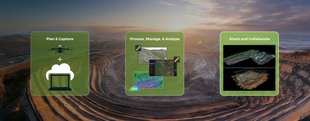
FLYGHT CLOUD: The Intelligence Engine Behind ideaForge UAVs
Collecting aerial data is only half the equation. The real value lies in how quickly and intelligently that data can be transformed into insight. That’s where FLYGHT CLOUD, ideaForge’s proprietary UAV data platform, comes in.
FLYGHT CLOUD enables mining teams to:
Aerial data collection is only half the story. How quickly and cleverly that data can be turned into insight is what really matters. ideaForge’s drone processing data platform, FLYGHT CLOUD, can help with that. Mining teams can do the following with FLYGHT CLOUD:
- After every mission, automatically convert drone data into high-resolution 2D orthomosaics and 3D models.
- Analyze volumetric data, track changes in the terrain over time, and look for anomalies such as tailings dam deformation or slope shifts.
- Real-time geospatial data visualization helps managers and field engineers track developments and identify hazards early.
- Work together remotely, securely sharing insights, maps, and annotations with stakeholders throughout the company.
Because FLYGHT CLOUD is deeply integrated with ideaForge UAVs, the entire workflow from flight to insight is seamless, fast, and purpose-built for high-demand environments like mining. FLYGHT CLOUD and ideaForge UAVs work together to provide a comprehensive mine intelligence platform that enhances safety and operational agility while cutting down on time-to-insight.
Supporting Autonomous and Connected Mining Ecosystems
As mining operations move towards autonomous haulage systems, smart drilling rigs, and control centers, UAVs become the driving force in this connected ecosystem.
UAVs are essentially moving nodes of data capture, uploading visuals, terrain information, and environmental data into mine-wide digital platforms perpetually. Whether it is surveillance of distant stockyards, inspection of railhead conditions, or examination of mission-critical infrastructure, drones provide visibility to every nook and cranny of the site.
Why ideaForge UAVs Are Built for Intelligent Mining
ideaForge provides intelligent, data-driven, rugged UAVs designed specifically for challenging mining environments. Our systems provide:
- Support for multiple payloads, such as RGB, LiDAR, thermal, and multispectral sensors
- Repeatable, automated flight routes for reliable data collection
- For large-scale sites, long flight durations and secure communications are ideal.
- Fast, cloud-based intelligence delivery through integrated processing through FLYGHT CLOUD
With deployments across challenging terrains, ideaForge drones are trusted for critical missions that require reliability and precision.
Conclusion: UAVs Are Mining’s Next Strategic Asset
The future of mining is autonomous, data-intensive, and sustainable. UAVs are no longer merely topographic mapping tools—today, they’re platforms for predictive analytics, operational insight, and strategic decision-making.
Through the adoption of UAVs and platforms such as FLYGHT CLOUD, US mining companies can increase productivity, maintain regulatory compliance, and act decisively quicker.
With ideaForge, mining operators get not only a drone—but an edge-to-cloud solution for smart mining.
Ready to turn your mine from mapped to smart?