Beyond Detection: How Drones Are Reshaping Wildfire Management and Forest Fire Recovery
Drones are becoming much more involved in fire management than just early detection, as wildfires are becoming more frequent and causing more damage. Unmanned aerial vehicles, or UAVs, are used today to assess risk, plan responses, assist in forest recovery, and locate active fires. This shift demonstrates a shift from merely keeping an eye out for fires to full-scale wildfire management aided by drone technology.
In this blog, we examine how the use of drones in wildfire management is enabling a more intelligent and responsive approach prior to, during, and following a fire.
Predicting Forest Fires with Drone-Based Risk Assessment
One of the fastest-growing applications of drones in fire management is pre-incident fire risk modeling. UAVs equipped with multispectral sensors and thermal cameras can survey forest density, monitor drought indicators, and map potential fuel loads. These regular aerial surveys help forest agencies create dynamic fire risk maps. These maps guide proactive actions like clearing dry vegetation or changing controlled burn schedules.
By making environmental monitoring a scalable aerial task, drones for forest fire prevention are helping shift the focus from emergency response to risk reduction.
Persistent Aerial Patrols in High-Risk Fire Zones
Due to delays, cloud cover, or uneven terrain, traditional firewatch techniques like satellite imaging or manned patrols frequently fail to detect the early warning signs of fire. UAVs use continuous surveillance missions to address these problems. During fire season, they patrol isolated and dangerous locations.
Automated drone patrols are being used by agencies to search for smoke plumes, lightning strikes, or illicit burning by flying along predetermined routes. The time from ignition to detection is greatly reduced by these UAV patrols. This provides firefighters with a significant edge in the early containment of wildfires.
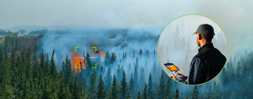
Enhancing Firefighting Operations with Real-Time Drone Intelligence
During an active wildfire, drones are essential for situational awareness. Thermal imaging in real time and high-resolution aerial video enable incident commanders to monitor fire behavior, detect flare-up areas, and guide suppression more effectively and safely.
Drones also provide ground tactical support, reporting GPS-stamped fire line information, wind data, and evacuation route feasibility. Therefore, UAVs in firefighting operations in the forest are enhancing multi-agency accuracy, coordination, and speed of operations in the field.
Post-Fire Assessment and Forest Recovery with Drones
Once a fire is contained, drones still play an important role. UAVs with mapping tools are now standard for assessing damage after a fire. They provide current images to measure burned land, evaluate damage to infrastructure, and look at ecosystem loss.
In the weeks and months that follow, drones are also used to monitor regrowth, spot soil erosion, and help reseed burned areas. These insights aid in making informed decisions about forest restoration planning and where to allocate funds.
Challenges and Future Trends in Drone Wildfire Management
Drones are increasingly being used for fire monitoring and control, but there are still obstacles to overcome. Full-area coverage may be limited by regulations pertaining to BVLOS (Beyond Visual Line of Sight) operations. Real-time data transmission may be slowed down by connectivity problems in mountainous or densely forested areas.
However, many of these issues are being addressed by continuing innovations such as satellite relays, edge computing, and long-endurance drone platforms. Drones will likely be more successfully incorporated into state and federal wildfire plans as interoperability advances. They will cooperate with conventional air fleets, satellite systems, and AI forecasting tools.
Conclusion: Drones as Full-Cycle Assets in Wildfire Resilience
This new phase of UAV integration extends well beyond fire detection. Drones are now essential tools throughout the wildfire lifecycle, from risk modeling and early warning to live fire management and post-event recovery.
For forest services, disaster agencies, and local governments, investing in drone wildfire surveillance systems is no longer something to think about for the future; it’s a necessary part of their operations. By incorporating drones into daily tasks and seasonal preparedness plans, organizations are strengthening their defense against the increasing threat of wildfires.