Introduction
The use of Unmanned Aerial Vehicles (UAVs) for 3D mapping is transforming sectors like construction, mining, and infrastructure development. With technological advancements, UAV 3D mapping offers unmatched precision, efficiency, and cost-effectiveness in surveying and volume estimation. This blog explores how UAV 3D mapping is boosting productivity, streamlining operations, and reducing costs in these industries.
The Evolution of UAV 3D Mapping for Industrial, Construction, and Government Applications
UAV 3D mapping has significantly evolved from its roots in aerial photography. Today, industries like construction and mining rely on drones for complex surveying and data collection. As drone technology advances, the accuracy of volumetric analysis and terrain modeling has improved, reducing the time needed for traditional ground-based surveys.
In the past decade, UAV 3D mapping has transitioned from an experimental technology to a core solution, especially in fields demanding high precision and real-time data. Initially adopted by agriculture and defense, the technology is now essential in construction, urban planning, and mining.
Rise in Demand for Precision-Driven Surveying Solutions Using Drones
As industries recognize the value of UAV 3D modeling, the demand for high-precision surveying solutions continues to grow. Drones enable mining operations to map hazardous terrain and accurately estimate volume, improving decision-making and site analysis. This precision is crucial for industries like mining, where accurate terrain mapping and volumetric analysis are essential for safety and efficiency.
What is UAV 3D Mapping?
UAV 3D mapping involves collecting three-dimensional data from a site using drones equipped with high-resolution imaging sensors, LiDAR, or photogrammetry cameras. The data is processed to create highly accurate 3D models of the area.
Basics of Drone-Based 3D Data Collection
Drone 3D mapping starts with the flight of a drone over the target area. Using high-resolution sensors, drones capture a series of images, which are then processed using photogrammetry algorithms to create detailed 3D models.
Photogrammetry, LiDAR, and Multi-View Stereo Techniques for Building Accurate 3D Models
Drones employ techniques like photogrammetry, LiDAR, and multi-view stereo to create 3D models. Each method serves different needs, offering unique advantages. LiDAR excels in dense vegetation or rough terrain, while photogrammetry delivers high-resolution imagery for clearer models.
Key Technologies Behind UAV 3D Mapping
- High-Resolution Aerial Imaging Sensors
Drones equipped with high-resolution cameras capture intricate details of terrain for precise 3D modeling, ensuring accuracy at every stage. - Precision GNSS and RTK Positioning for Mapping Accuracy
Global Navigation Satellite Systems (GNSS) and Real-Time Kinematic (RTK) systems offer centimeter-level positioning accuracy, which is critical in industries like mining where precise measurements are necessary. - Advanced 3D Data Processing Software and Cloud Platforms
Post-processing 3D data requires advanced software and cloud platforms like FLYGHT CLOUD, which facilitate real-time collaboration and decision-making across teams, especially in large-scale projects like mining or construction.
Industrial and Government Applications of UAV 3D Mapping
UAV 3D mapping has diverse applications across industries, including infrastructure development, land management, and natural resource management.
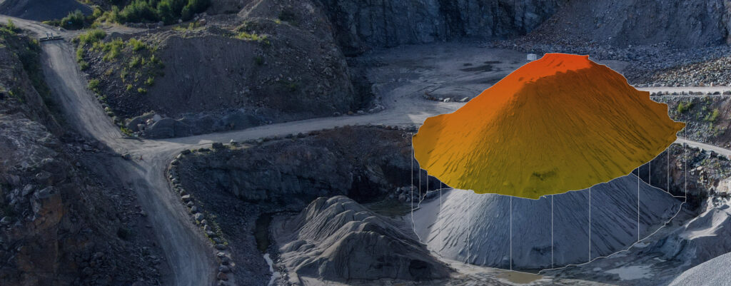
- Mining Site Volumetric Analysis
Drones are invaluable in mining for volumetric analysis of stockpiles, excavation sites, and open-pit mining operations. Accurate volume measurements optimize operations, reduce waste, and enhance safety. - Infrastructure Development and Monitoring
In construction, UAVs equipped with high-resolution sensors allow for continuous project monitoring. Drones help track excavation progress, site planning, and compliance, significantly increasing productivity. - Disaster Management and Rapid Terrain Mapping
In disaster-stricken areas, drones provide rapid terrain mapping, helping emergency responders assess damage and plan rescue operations quickly.
Advantages of UAV 3D Mapping Over Traditional Methods
UAV 3D mapping offers several advantages over traditional surveying methods:
- Time Efficiency, Precision, and Cost Reduction
Drones cover vast areas quickly, cutting down survey time significantly. UAVs also eliminate the need for costly equipment and labor-intensive data collection. - Higher Detail and Safety Improvements
High-resolution sensors provide detailed mapping that traditional methods can’t match. Additionally, UAVs keep survey teams out of hazardous areas, improving safety.
ideaForge Solutions for Professional UAV 3D Mapping
ideaForge provides advanced UAVs, such as the NETRA V4 PRO and Q6 V3, designed specifically for 3D mapping. These drones support high-end payloads like photogrammetry, LiDAR, and multispectral sensors, ensuring accurate data capture across industries.
Factors to Consider Before Implementing UAV 3D Mapping
When implementing UAV 3D mapping, consider the following:
- Regulatory Compliance– Ensure the drones comply with local regulations for survey-grade operations.
- Payload Selection – Choose appropriate payloads, like cameras or LiDAR, based on project requirements.
- Pilot Certification – Certified UAV operators ensure safe and accurate data collection.
Challenges in UAV 3D Mapping and How to Overcome Them
While UAV 3D mapping is revolutionary, challenges like weather conditions, terrain accessibility, and data processing bottlenecks can arise. Proper planning, equipment selection, and protocols can mitigate these issues.
Future Trends in UAV 3D Mapping
- AI-Enhanced Data Analysis
Artificial intelligence will enhance data processing, automate analysis, and provide deeper insights from 3D models. - Integration with GIS Platforms
Integrating UAV data with Geographic Information Systems (GIS) will enable sophisticated spatial decision-making. - UAV Swarms for Large-Area Mapping
UAV swarms will enable faster, more efficient surveys across large areas, ideal for mining sites and infrastructure projects.
Why Choose ideaForge for UAV 3D Mapping Solutions
With a track record of successful deployments, ideaForge leads the way in UAV solutions tailored to industries like mining, construction, and government. Our UAVs offer robust, reliable, and customizable solutions for precise surveying, mapping, and data analysis.
Conclusion
UAV 3D mapping is no longer a trend but a critical technology for industries requiring high-precision surveys. Early adoption offers significant advantages, improving efficiency, safety, and reducing costs.
Why Early Adoption Ensures Better Project Outcomes
By adopting UAV 3D mapping early, companies gain a competitive edge through streamlined data collection, improved accuracy, and reduced operational costs.
FAQs
- What is UAV 3D Mapping?
UAV 3D mapping uses drones to collect data and create detailed 3D models of terrains, construction sites, or mining areas. - How accurate is 3D Mapping with drones compared to traditional surveying?
UAVs achieve centimeter-level accuracy, often surpassing traditional methods in speed and precision. - Can UAV 3D mapping replace ground-based surveys completely?
UAV 3D mapping complements traditional methods but is often used alongside them to ensure comprehensive data collection. - Which industries benefit most from UAV 3D mapping?
Mining, construction, agriculture, urban planning, and more benefit from drone mapping services. - What UAV platforms are best for 3D mapping missions?
ideaForge’s NETRA V4 PRO and Q6 V3 are ideal for high-precision 3D mapping, offering advanced payload options and robust performance.
How does ideaForge support UAV 3D mapping projects for government departments?
ideaForge offers custom UAV solutions, pilot training, and ongoing support to meet the specific needs of government projects, ensuring efficient and reliable data collection.
Reimagine your mining operations with high-endurance UAVs that deliver results. To learn more – Contact Us.